 flights to accurately map the condition of macadamia trees in Australia. © 2020 Kaspar Johansen")
Researchers Kasper Johansen and Matthew McCabe at KAUST’s Water Desalination and Reuse Center, with co-workers in Australia, have demonstrated the potential of using combined data from satellite and unmanned aerial vehicle (UAV) flights to accurately map the condition of macadamia trees in Queensland. Macadamia nuts are an important export for Australia, but the trees take 15 years to mature and provide their maximum yield, so farmers must identify early any trees that are suffering. “Currently, macadamia farmers rely on manual visual assessment of each tree and its irrigation system, which is time-consuming and often inconsistent”, says Johansen, “whereas UAV and satellite remote sensing could evaluate thousands at a time.”
The team studied three plantations containing trees of various ages and varieties. The health of each tree was assessed by an experienced agronomist using a five-point scale from excellent to poor condition. The researchers flew a UAV over the sites to record spectral images in green, red and near infrared, and they acquired data across several more spectral bands from the Worldview-3 earth observation satellite. Using training data from a few hundred trees, the team developed models relating the spectral data to the ground measurements. The models were then able to correctly classify over 98 % of the other trees.
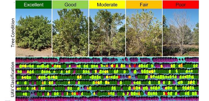
By combining data from UAV and satellite surveys, Johansen and co-workers were able to classify the health of individual trees on a five-point scale across large areas of macadamia plantations. Farmers can then use a map, like the one shown, to find and treat trees at risk. © 2020 Kaspar Johansen
Interestingly, although the detailed spectra from Worldview-3 provided the most accurate models of tree health, the pixel size of 1.2-m was too coarse to identify individual tree crowns, which could only be done with the high-resolution UAV data. This highlights the benefits of a combined UAV-satellite approach.
Their work was published in ISPRS Journal of Photogrammetry and Remote Sensing.


 cells in treated tumour cells")


 generate an RGB video image, the newly developed laparoscope (left) uses a multispectral camera. This also makes it possible to visualise functional properties of the tissue. Source: Leonardo Ayala / DKFZ")